top of page

UTD GEONEWS

2018 LOGO.png
utd geonews.png
Science Behind the 2020 Sparta, North Carolina Earthquake
03:40
UTD GEOSCIENCE STUDIO

Science Behind the 2020 Sparta, North Carolina Earthquake

In August 2020, the town of Sparta, North Carolina experienced a magnitude 5.1 earthquake, the largest earthquake seen in the area since 1916. This region is nowhere near a plate boundary where we see the most earthquakes. So why does this area get earthquakes despite being so far away from these boundaries? To find out we go back in time hundreds of millions of years ago when continents were colliding. Our website: https://utdgss2016.wixsite.com/utdgss Twitter: https://twitter.com/utdgss2016 Instagram: https://www.instagram.com/utd_geosciencestudio/ Credits Edited by Zach Clowdus Written by RJ Stern & Zach Clowdus References Hatcher, R. D. Jr. (1987). Tectonics of the southern and central Appalachian internides. Annual Reviews of Earth and Planetary Science, 15, 337–362 Hatcher, R. D. Jr. (1987). Tectonics of the southern and central Appalachian internides. Annual Reviews of Earth and Planetary Science, 15, 337-362 Usgs.gov Music – “Dude, Where’s My Horse” by Nat Keefe with The Bow Ties Earthquake map – usgs.gov Plate Tectonic Globe – Paleogeographic maps by C.R. Scotese, visualization developed by Ian Webster https://dinosaurpictures.org/ancient-earth#300 Cross Section Modification from https://gotbooks.miracosta.edu/geology/regions/blue_ridge.html Image - Blue Ridge Mountains Deep Gap overlook on the Blue Ridge Parkway in western North Carolina via Wikimedia Commons Fault Mechanism Solutions and Fault Block diagrams modified from usgs.govhttps://pubs.er.usgs.gov/publication/sim3446 Google Maps Sounds: “Thunder” by straget via freesound.org “Rope being swing” by ChaleneZ via freesound.org “Rocks Sliding” by yatoimtop via freesound.org #geonews
Science Behind Nevada's 2020 Earthquake
05:00
UTD GEOSCIENCE STUDIO

Science Behind Nevada's 2020 Earthquake

In the early morning of May 15, 2020, a magnitude 6.5 earthquake shook Nevada awake. The largest since 1954! This quake occurred in a fascinating seismically active area called The Walker Lane. Learn about this and the Mina deflection from the geologists at UT Dallas’ GeoScience Studio - Special thanks to our scientific advisors for this episode – Dr. Nick Mueller and Dr. Scott Kerstetter for their invaluable information on the Mina deflection and the surrounding area and thanks to Dr.Timothy Dixon and Taha Chorsi for their work with the interferometry figures used in this episode Written By – R.J. Stern, Ning Wang, Zach Clowdus, Scott Kerstetter, Nick Mueller Presentation and Narration – Ali Sealander Video Editing – Zach Clowdus Opening Title Animation – Alayna Wilson References and Papers for the nerds! Kerstetter, S. R., 2018. Late Oligocene to Early Miocene North-South Extension in the Western Great Basin (Doctoral dissertation, U TX Dallas). Link to Kerstetter dissertation: https://utd-ir.tdl.org/bitstream/handle/10735.1/6253/ETD-5608-014-KERSTETTER-8517.09.pdf?sequence=5 Mueller, N. J., 2019. Pliocene Kinematic Reorganization, Fault Geometry, Basin Evolution, and Displacement Budget Along the Furnace Creek–Fish Lake Valley Fault Zone, Eastern California and Western Nevada (Doctoral dissertation, U TX Dallas). Link to Mueller dissertation: https://utd-ir.tdl.org/bitstream/handle/10735.1/6883/ETD-5608-014-MUELLER-260174.63.pdf?sequence=5&isAllowed=y “Splitting North America – The Walker Lane – Part 1 – The Tectonics” https://volcanohotspot.wordpress.com/2018/09/21/splitting-north-america-the-walker-lane-part-1-the-tectonics/ Carlson, C.W.; Pluhar, C.J.; Glen, J.M.G., and Farner, M.J. 2013. Kinematics of the west-central Walker Lane: Spatially and temporally variable rotations evident in the Late Miocene Stanislaus Group. Geosphere; 9 (6): 1530–1551. Ryall, A., and Priestley, K., 1975, Seismicity, secular strain, and maximum magnitude in the Excelsior Mountains area, western Nevada and eastern California, Geological Society of America Bulletin v. 86, no. 11, 1585-1592. Albers, J. P., and Stewart, J.H., 1965. Preliminary Geologic Map of Esmeralda County, Nevada. USGS Miscellaneous Field Studies Map MF-298 https://ngmdb.usgs.gov/Prodesc/proddesc_2718.htm Additional Credits Sounds Radar – By Eschwabe3 from Freesound.org (https://freesound.org/s/459838/) Heavy Thunder – By BlueDelta from Freesound.org (https://freesound.org/s/446753/) Rock Scrape – By Benboncan from Freesound.org (https://freesound.org/s/74442/) Slot machine – By JoannaLuna from Freesound.org (https://freesound.org/s/448842/) Images Las Vegas sign - Thomas Wolf, www.foto-tw.de Gold – Photo by Getty Emigrant Peak Fault and other field images – Scott Kerstetter & Nick Mueller Fault Map – MyHAZARDS – Nevada from gisweb.unr.edu/MyHAZARDS/ Group of miners - Unknown author / Public domain from commons.wikimedia.org Desert Mountains – By Rana Obaid from Pexels.com Interferogram and Displacement Map – Timothy Dixon & Taha Chorsi By VisionPic.net from Pexels Nevada Mountains – Sydnet Martinez/TravelNevada from flickr.com (https://www.flickr.com/photos/travelnevada/16685527363/in/photostream/) Earthquake Aftershocks – earthquake.usgs.gov Image of Satellite – ESA/ATG medialab (https://www.esa.int/ESA_Multimedia/Images/2014/01/Sentinel-1_radar_vision) Image of Silver Mineral - https://geologyscience.com/minerals/silver/ Videos Compass – By Miguel A. Padrinan from Pexels.com Maps made with google.com/maps

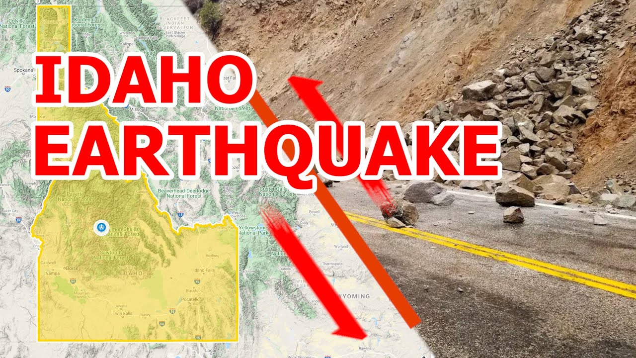
EP8. Science Behind Idaho's 2020 Earthquake - UTD GeoNews

Learn about the magnitude 6.5 earthquake that struck Idaho on March 31, 2020 from UT Dallas' GeoScience Studios. This was the highest magnitude earthquake that Idaho has seen in over 35 years!

EP7.Science of the Magnitude 5.0 Mentone (TX) earthquake

(March 26, 2020)

GSS is here to tell you about a temblor that tickled Texas recently. A little after 10 in the morning on March 26, a moderate earthquake struck far West Texas, about 25 miles west of the small town of Mentone.

EP6.Science of the Magnitude 5.7 Magna, Utah earthquake

(March 18, 2020)

GSS is here to tell you about the science behind the Wednesday, March 18 earthquake that happened near Magna, Utah, not far from Salt Lake City. The earthquake struck a little after 8 in the morning and was magnitude 5.7.

EP5.Taal Volcano Eruption 2020

Learn about the 2020 Eruption of the Taal Volcano from the geologists at UT Dallas' Geoscience Studio.

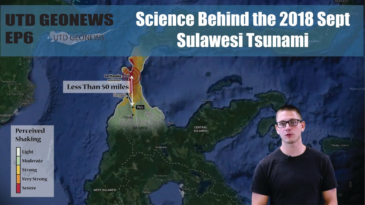
Ep4.Science Behind the 2018 Sept Sulawesi Tsunami 

This Geonews video is about the tsunami that struck Indonesia, on the Island of Sulawesi in Indonesia on Friday, September 28th. This earthquake and tsunami is in the news because these claimed many lives and disrupted the lives of many others. The origin of this tsunami was a bit unusual and worth learning more about.

Ep3.Science Behind the 2018 Sept Sulawesi Tsunami 

Learn more about the Science Behind Hawaii Eruption 2018!

Ep2.What's happened inside Siberia's Mysterious Craters? An Overview of Methane Hydrate

Have ever heard of Siberia's Mysterious Craters occurred from no where? Have ever heard of Methane Hyrate? Learn the science behind the mystery and the potentially important future energy from this video!

Ep2.Is the Earth falling apart!? Science Behind the Earth Suswa Fissure (Kenya) of 2018 

A fissure has opened near the capital city of Nairobi in the nation of Kenya in East Africa. This is called the Suswa Fissure. As of March 20th the fissure was as deep as 50 ft and 65 ft wide! 

Ep1.Science Behind the Biggest Global Hazard in Feb 2018, the Sinabung Volcano Eruption! 

One of the Asian most active volcanoes, Mount Sinabung, exploded on Feb 19, and created a 5 kilometers volcanic ash plume into the air. But, why is the explosion so violent? It is because the Mont Sinabung locates at the Indo-Australian and Eurasian convergent plate margin.

bottom of page